


IT-366

SityTrail - itinéraires balisés pédestres
Tous les sentiers balisés d’Europe GUIDE+

Lengte
7,2 km

Max. hoogte
2281 m

Positief hoogteverschil
496 m
Km-Effort
16,8 km

Min. hoogte
905 m

Negatief hoogteverschil
1380 m
Boucle
Neen

Markering
Datum van aanmaak :
2022-02-15 00:33:53.188
Laatste wijziging :
2022-02-28 19:25:56.074
3h48
Moeilijkheid : Gemakkelijk

Gratisgps-wandelapplicatie
 SityTrail
IGN / Geografische instituten
SityTrail Plus
De wereld gaat voor u open
Over ons
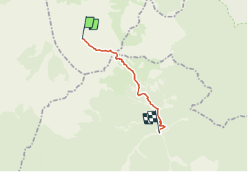
Tocht Te voet van 7,2 km beschikbaar op Friuli-Venezia Giulia, Onbekend, Forni di Sopra. Deze tocht wordt voorgesteld door SityTrail - itinéraires balisés pédestres.
Beschrijving
Trail created by Club Alpino Italiano.
Foto's


Plaatsbepaling
Land:
Italy
Regio :
Friuli-Venezia Giulia
Departement/Provincie :
Onbekend
Gemeente :
Forni di Sopra
Locatie:
Unknown
Vertrek:(Dec)
Vertrek:(UTM)
310868 ; 5138447 (33T) N.
Opmerkingen